
Custom NOAA Chart
Price range: $34.99 through $84.99
Important: When uploading your custom chart, please include your name in the uploaded document. Example: YourName_NOAAChartCustom.pdf
Please confirm that the size of the map you select below matches the size of the map you are uploading.
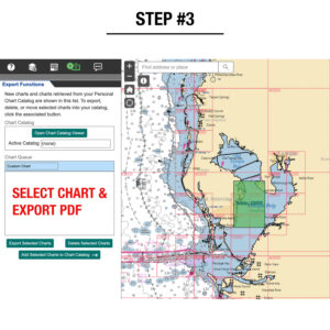
The Map Shop can print and apply our finishing options to any custom map created by the NOAA Custom Map Program. Explore the depths of oceanographic data with their innovative tool empowers users to search and generate custom charts of the waters most important to them.
Key Features:
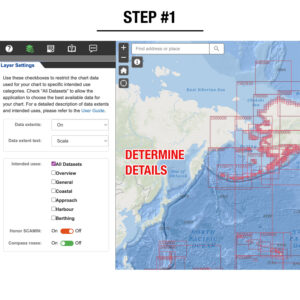
- Interactive Mapping: Navigate through detailed maps showcasing a range of data layers such as bathymetry, sea surface temperatures, and ocean currents. Customize your view by toggling layers and adjusting opacity to focus on specific parameters.
- User-Friendly Interface: Designed for seamless navigation, our interface allows effortless zooming, panning, and switching between base maps like satellite imagery or topographic views.
- Data Interaction: Click on map points to access detailed data points and metadata, providing deeper insights into marine environments and conditions.
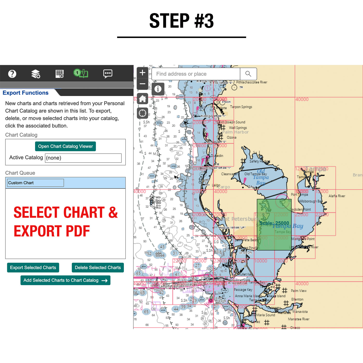
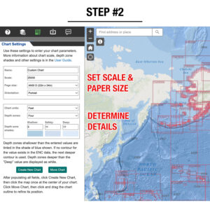
- Custom Map Creation: Tailor maps to your needs by selecting desired data layers and generating custom map views. Save or export these configurations for future reference or sharing.
- Print Your Custom Maps: Upload your PDFs directly on our product page to print bespoke maps, perfect for presentations, fieldwork, or wall displays. Enjoy the convenience of having personalized maps ready for any occasion.
Please note: Map Shop is unable to provide support on how to use the NOAA Custom Map Program so please review NOAA’s User Documentation for instructions. If you would like the Map Shop to create a custom map for you, please contact us here for details.
Please confirm that the size of the map you selected above matches the size of the map you are uploading. If you upload a size that is different from the size selected, your map will appear blurry and unreadable.
Returns
We do not offer returns on any custom map but if you’re unhappy with how your chart was printed or finished, we are happy to replace it. We are not able to re-print or re-finish maps for free if you sent us the incorrect map or if you need changes to your map. Please make sure the file that you send us is the approved map ready for print. Thank you.
What Is a Nautical Chart?
A nautical chart is one of the most important tools available to mariners. It is a specialized map that shows the configuration of the shoreline and seafloor, water depths, hazards to navigation, aids to navigation, anchorages, and other critical features. These charts have been essential for safe navigation, helping mariners plan voyages and guide vessels safely and efficiently. Federal regulations require most commercial ships in U.S. waters to carry nautical charts. Since the 1830s, the U.S. Coast Survey (now NOAA’s Office of Coast Survey) has served as the official nautical chartmaker for the United States, producing and maintaining charts of coastal waters, the Great Lakes, and U.S. territories.
Paper Charts Are No Longer Updated
NOAA officially phased out its traditional paper nautical charts in January 2025. They are no longer updated and should not be used for navigation. Any changes made after their final edition are reflected only in NOAA’s electronic navigational charts (ENCs). This means that the paper charts we offer today are best suited for decoration and display, not active use on the water.
The Decorative Value of NOAA Charts
Even though paper charts are no longer maintained for navigation, they remain highly valuable as decorative pieces. Their clean style, coastal detail, and maritime history make them excellent for homes, offices, and gifts. Most chart updates over the years were minor - often related to aids to navigation or harbor changes, not details needed for decorative display. That makes these charts timeless in appearance, even if not current for navigation.
NOAA Seal and Logo Options
As an NOAA Certified Printer, we have the ability to include the official NOAA seal on your chart. This designation shows that the chart was produced under NOAA’s standards. However, not everyone needs the seal for display purposes. If you prefer a cleaner look, simply select the checkbox labeled “For Decoration” and we will remove both the NOAA seal and the Map Shop logo from your chart.
Create Your Own Custom NOAA Chart
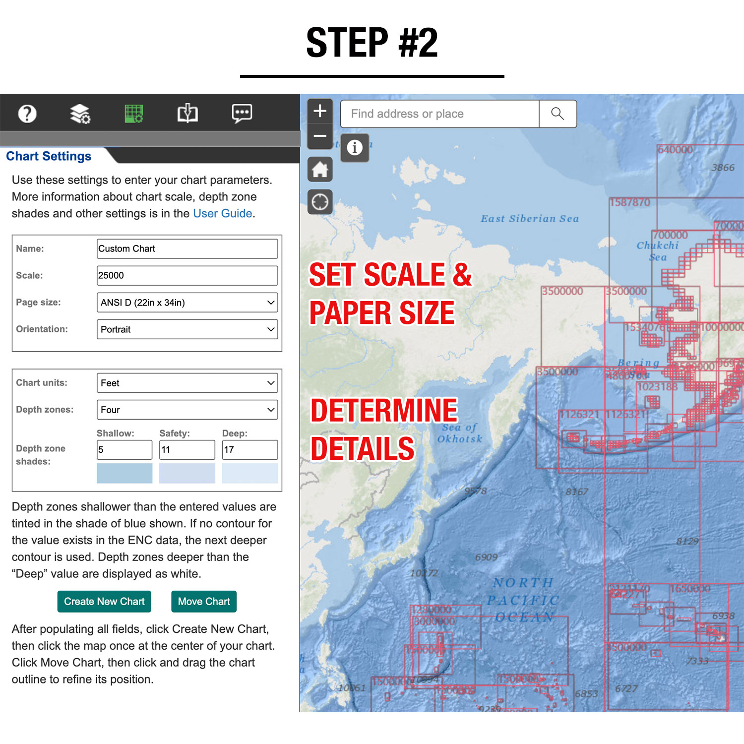
If you’re looking for a personalized piece, explore our Custom NOAA Chart Program. This tool allows you to choose any area covered by NOAA’s database, adjust the scale and paper size, and create a one-of-a-kind chart centered exactly where you want it. It’s perfect for highlighting a favorite harbor, sailing route, or coastal property. Once ordered, we’ll print your chart on high-quality paper with the same standards as NOAA’s official products.
Map Finishing Options
Transform your wall map into a ready-to-hang centerpiece! Our professional framing and railing services often cost less than visiting a local framer. Choose your finishing option during checkout and receive your map ready to display immediately and hassle-free.
Paper
Paper finishing is the most economical option. Most maps are printed on premium 36lb paper. Waterproof paper is also available for functional maps that may be used outdoors.
Laminated
Maps are printed, then run through our laminator that applies 1.7mil-thick satin-gloss lamination to the front and back. You can use map stickers and wet-erase markers.
Mounted
Maps are printed, then laminated with 1.7mil-thick satin lamination onto 1/4″-thick foam core. You can use map pins, stickers, or wet-erase markers with our mounted maps.
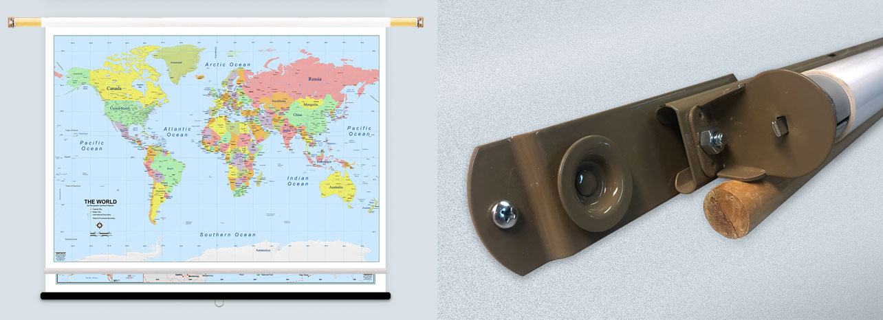
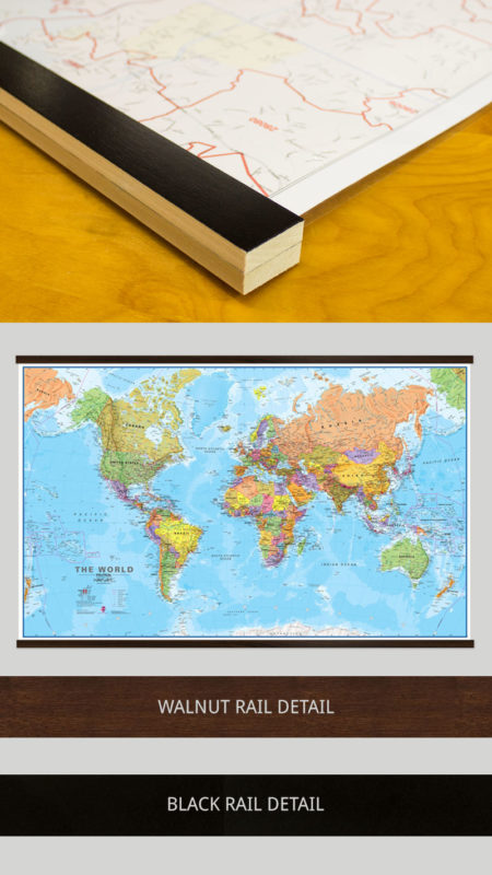
Laminated with Rails
First, we laminate the map, then mount wood rails at the top and bottom. The front side of each rail features a black or walnut finish, while the sides and back are unfinished wood. Sawtooth hardware is attached to the back of the top rail so it's ready to hang. You can use stickers or wet-erase markers on your laminated map. We recommend a mounted or framed option if you'd like to use map pins to mark locations.
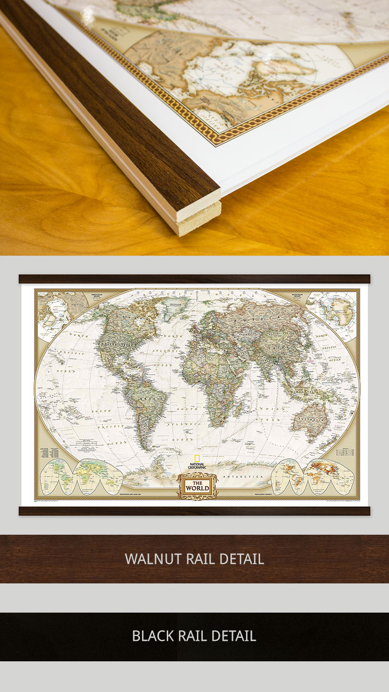
Mounted with Rails
First, we laminate the map onto foam core, then mount wood rails at the top and bottom. The front side of each rail features a black or walnut finish, while the sides and back are unfinished wood. Sawtooth hardware is attached to the back of the top rail so it's ready to hang. You can use map pins, stickers, or wet-erase markers on your map. This option will lay clean and flat against the wall, unlike the laminated with rails option.
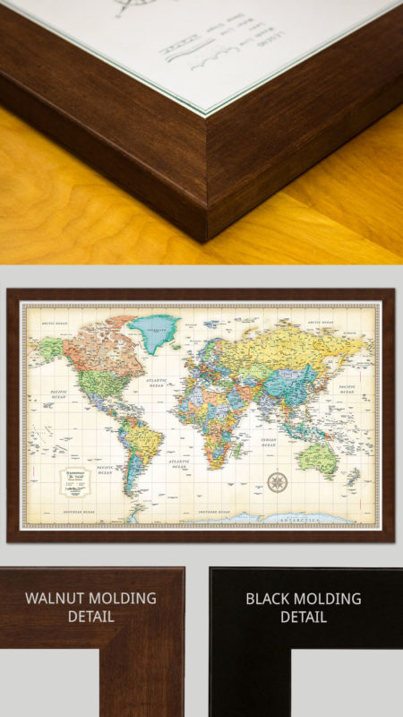
Framed
Maps are laminated onto foam core, then secured into the frame. The engineered molding is made from recycled wood in either a black or walnut finish that wraps around the entire map. Most moldings are 2″ wide by 3/4″ deep, but maps 24″ x 36″ and smaller use a 1.25″ wide molding. You can use map pins, stickers, or wet-erase markers on all our framed maps. Ready-to-hang sawtooth hardware or wire hanging loops are included.