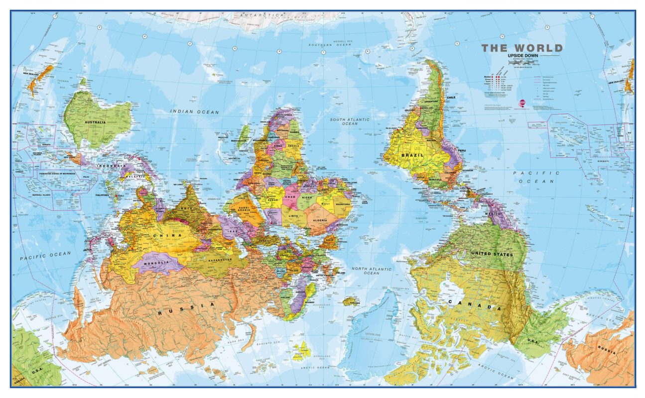
Asking the Important Questions:
Are Maps Upside Down in Australia?
Australia is an interesting place. Full of gorgeous, one-of-a-kind sights to visit. Its a surfers paradise, home of the boomerang, the didgeridoo, and some of the most adorable animals on the planet; and seriously good coffee. It has earned its spot among the world’s best tourist locales. However, as much as people love traveling to the land of kangaroos and Vegemite, outsiders don’t always fully get it.

In addition to the mindblowing phenomena of counter clockwise toilet flushes, visitors to Australia can be daunted with its seemingly endless amount of venomous critters to its chaotic sometimes dangerous weather. Oh, and there’s that whole “it’s a country but also a continent thing,” too. All of these often leave folks with lots of questions, but one, in particular, has received a lot of internet attention lately: are maps upside down in Australia?
Offering a Little Context
Yeah, we’re really asking the important things, aren’t we?
Australia’s reputation as the land down under. It actually comes from the fact that their maps do look different than the ones us Northern Hemisphere folks might use or remember from our time in the classroom, and this is because the orientation of maps in Australia can be a little bit outside what you may consider “normal”.
Just as a comparison, a traditional map looks somewhat well-balanced. Typically portrayed with Alaska, Canada, Greenland, and Russia touching the topmost edge of the page and places like Australia and Antarctica positioned at the bottom, what we’ve come to know as the kind of standard world map follows a “north-up” orientation.
But in Australia? They go about things in a different fashion. Rather than using this conventional sort of map, they use one that instead positions Australia at the top with Canada, Russia, and others in the southern quadrants. In other words, the orientation is completely flipped to what we associate as the norm, making it look, well, upside down.

So, Is It Upside Down?
This type of mapping seems weird for the majority of us. But does this actually mean that our Aussie friends are looking at the world in a “wrong” way or that they’re using maps that are genuinely “upside-down” in nature? Relatively speaking – the short answer is no.
The Australian map may seemingly have a strange format, but it’s not upside down at all. Sure, it’s a deviation in convention, an alternative way of looking at the world around us. However, it does not undermine factuality or offer any misrepresentation, as some suggest. Why? Because the more traditional way of representing the world - with north up and south down - is in no way more (or less) valid.

Remember, the Earth is not a flat object nor something with one, absolute orientation. It’s a globe, a sphere that is constantly rotating and will always look different depending on where its viewer is positioned. Look at it from various points in space, and it won’t appear the same. Oceans and land will seem scrambled, countries in an order that would make identification difficult without any directional hints.
This is the nature of our planet; there is no such thing as “right-side up.” All views of it are equally accurate, including the way Australians portray it on their map. Still not totally sold? You’re likely not the only one. Rendering our 2D maps outside the norm seems like an odd choice to many but let’s not forget, even NASA showcases images of different orientations. It’s not purely exclusive to just Australia.
Reason for the Difference
Okay, okay. So our friends in the land of marsupials aren’t technically using an upside-down map. But they still are using a representation that goes against what’s used in most other countries. There has to be a reason for that, right? We give you two thumbs up for that thought because you’re absolutely right.
You see, mapping isn’t objective and devoid or devoid of POV. Like pretty much everything else in our world, it’s positively steeped in politics and biases in perception. Who’s in power, the nationality of the cartographer behind the map, the current landscape of international relations - all of these and more play a role in how a map is ultimately portrayed.
This is obvious when you take a look at the typical world map, which is officially known as the Mercator projection. People in the northern hemisphere, particularly those in North America and Europe, have historically held much of the world’s political power. We’re still a teensy (fine, a lot) obsessed with northern culture, a fact that has dramatically influenced how we make our maps and is the reason why the Mercator projection and other north-up alternatives have become the norm.
Australia has basically just become tired of this, as they probably should. Mercator maps relegate them to a footnote on the page and minimize their importance by pushing much of the focus on northern countries. They’ve then essentially made the Australian map as a reaction to this, literally elevating them from the land down-under to a country worthy of central focus

