What Are United States Raised Relief Maps?
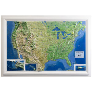
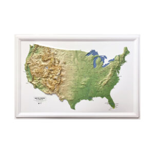
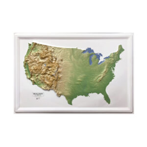
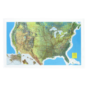
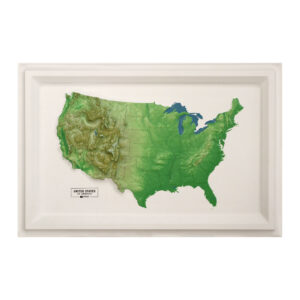
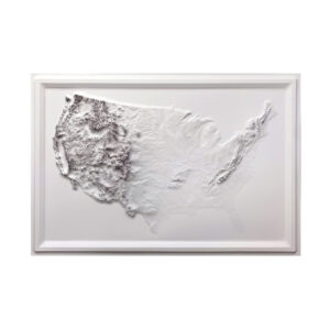
United States raised relief maps are three-dimensional representations of the country’s physical terrain. These maps are molded using real elevation data and highlight features such as mountain ranges, basins, plains, and coastal regions. Made from rigid vinyl and vacuum-formed over carved molds, they provide both visual accuracy and tactile depth. They’re a favorite for schools, government offices, and anyone looking to display the physical layout of the U.S. in a format that brings the landscape to life.
United States raised relief maps are three-dimensional representations of the country’s physical terrain. These maps are molded using real elevation data and highlight features such as mountain ranges, basins, plains, and coastal regions. Made from rigid vinyl and vacuum-formed over carved molds, they provide both visual accuracy and tactile depth. They’re a favorite for schools, government offices, and anyone looking to display the physical layout of the U.S. in a format that brings the landscape to life.
What Can You See on a U.S. Relief Map?
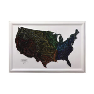
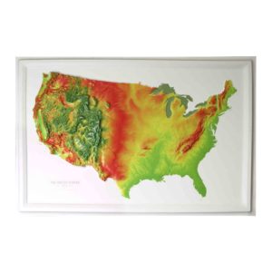
A U.S. raised relief map shows major landforms like the Rocky Mountains, Sierra Nevada, Appalachian Mountains, Mississippi River Basin, and Great Plains. Some models also include lakes, rivers, and state boundaries. These maps are labeled with cities, regions, and key physical features, making them useful for both reference and display. They’re ideal for anyone studying or teaching the geography of the United States.
A U.S. raised relief map shows major landforms like the Rocky Mountains, Sierra Nevada, Appalachian Mountains, Mississippi River Basin, and Great Plains. Some models also include lakes, rivers, and state boundaries. These maps are labeled with cities, regions, and key physical features, making them useful for both reference and display. They’re ideal for anyone studying or teaching the geography of the United States.
Why Choose a 3D Map of the United States?
Flat maps show locations and boundaries, but a raised relief map gives you a deeper understanding of the land itself. Being able to physically feel the elevation helps make concepts like mountain ranges, river valleys, and coastal plains more intuitive. These maps are especially effective for students, geographers, travelers, and outdoor enthusiasts who want a more immersive way to understand the U.S. landscape.
Flat maps show locations and boundaries, but a raised relief map gives you a deeper understanding of the land itself. Being able to physically feel the elevation helps make concepts like mountain ranges, river valleys, and coastal plains more intuitive. These maps are especially effective for students, geographers, travelers, and outdoor enthusiasts who want a more immersive way to understand the U.S. landscape.
Are These Maps Accurate?
Yes. Our United States raised relief maps are made using verified elevation data from trusted sources like the U.S. Geological Survey. The molded terrain reflects real topography, with some vertical exaggeration to highlight elevation changes. Every map is reviewed for clarity, scale accuracy, and legibility, ensuring it works well for educational, reference, or decorative use.
Yes. Our United States raised relief maps are made using verified elevation data from trusted sources like the U.S. Geological Survey. The molded terrain reflects real topography, with some vertical exaggeration to highlight elevation changes. Every map is reviewed for clarity, scale accuracy, and legibility, ensuring it works well for educational, reference, or decorative use.
Can You Frame a United States Raised Relief Map?
Yes, and it looks incredible. While these maps should not be framed under glass, they can be displayed in open frames or shadowboxes that preserve the three-dimensional surface. Some models include a molded edge to enhance structure, and a wood frame can add a finished look that makes the map a centerpiece for your space. Framing elevates the visual impact and makes the map ideal for office walls, classrooms, or public displays.
Yes, and it looks incredible. While these maps should not be framed under glass, they can be displayed in open frames or shadowboxes that preserve the three-dimensional surface. Some models include a molded edge to enhance structure, and a wood frame can add a finished look that makes the map a centerpiece for your space. Framing elevates the visual impact and makes the map ideal for office walls, classrooms, or public displays.
Are These Maps Good for Education?
Absolutely. Raised relief maps of the United States are excellent tools for teaching U.S. geography, geology, and landform studies. They help students understand the relationship between elevation and population, climate, or natural resources. Tactile learners benefit especially from being able to explore the terrain with their hands. These maps are used in elementary through college-level classrooms across the country.
Absolutely. Raised relief maps of the United States are excellent tools for teaching U.S. geography, geology, and landform studies. They help students understand the relationship between elevation and population, climate, or natural resources. Tactile learners benefit especially from being able to explore the terrain with their hands. These maps are used in elementary through college-level classrooms across the country.
What Size Are United States Relief Maps?
Most United States raised relief maps are sized between 30 and 40 inches wide. This makes them large enough to clearly show terrain features while still being manageable for classroom or wall display. Each product page includes exact dimensions and available framing options.
Most United States raised relief maps are sized between 30 and 40 inches wide. This makes them large enough to clearly show terrain features while still being manageable for classroom or wall display. Each product page includes exact dimensions and available framing options.
What Is the Hubbard Scientific Brand?
Hubbard Scientific is a respected name in educational maps and has been producing raised relief maps for more than 60 years. The Map Shop is the sole manufacturer of all Hubbard Scientific maps, continuing that legacy of quality and educational value. These maps are made in the United States and are known for clear labels, strong terrain detail, and classroom durability. Learn more about the Hubbard Scientific brand and history here.
Hubbard Scientific is a respected name in educational maps and has been producing raised relief maps for more than 60 years. The Map Shop is the sole manufacturer of all Hubbard Scientific maps, continuing that legacy of quality and educational value. These maps are made in the United States and are known for clear labels, strong terrain detail, and classroom durability. Learn more about the Hubbard Scientific brand and history here.
Why Buy U.S. Raised Relief Maps from The Map Shop?
The Map Shop is the exclusive manufacturer of all Hubbard Scientific raised relief maps. We’ve been helping people explore the world through maps since 1990, and our U.S. raised relief maps are selected for their quality, accuracy, and visual appeal. Whether you’re outfitting a classroom, decorating an office, or adding to your personal collection, our team in Charlotte, NC is here to help you find the perfect map for your needs.
The Map Shop is the exclusive manufacturer of all Hubbard Scientific raised relief maps. We’ve been helping people explore the world through maps since 1990, and our U.S. raised relief maps are selected for their quality, accuracy, and visual appeal. Whether you’re outfitting a classroom, decorating an office, or adding to your personal collection, our team in Charlotte, NC is here to help you find the perfect map for your needs.