


What Are Raised Relief Maps?
Raised relief maps are three-dimensional maps made from molded rigid vinyl that visually and physically represent elevation changes across terrain. They don’t just illustrate geography—you can actually feel it. Mountains rise off the surface, valleys dip inward, and landforms take shape in a way that flat maps can’t replicate. These maps are created by our skilled professionals who model the geography using elevation data, carve a mold, then print and vacuum-form the maps. The result is a hand-made, realistic, and tactile model of the landscape with exceptional detail. Popular among classrooms, offices, and travel enthusiasts, they offer an engaging way to explore topography. Want a deeper look at how they’re made and why they matter? Read our full guide to raised relief maps here.
Raised relief maps are three-dimensional maps made from molded rigid vinyl that visually and physically represent elevation changes across terrain. They don’t just illustrate geography—you can actually feel it. Mountains rise off the surface, valleys dip inward, and landforms take shape in a way that flat maps can’t replicate. These maps are created by our skilled professionals who model the geography using elevation data, carve a mold, then print and vacuum-form the maps. The result is a hand-made, realistic, and tactile model of the landscape with exceptional detail. Popular among classrooms, offices, and travel enthusiasts, they offer an engaging way to explore topography. Want a deeper look at how they’re made and why they matter? Read our full guide to raised relief maps here.
What Types of Raised Relief Maps Are Available?
We carry a wide selection of raised relief maps, organized by region and purpose. Our collection includes detailed maps of the World, the United States, individual U.S. states, USGS Regions, National Parks, and some maps that fall outside these categories. Looking for a broad overview? Try a raised relief map of the world or the full United States. Need more localized detail? Browse our state maps like California, Colorado, or North Carolina. Explore all styles to find the perfect fit.
We carry a wide selection of raised relief maps, organized by region and purpose. Our collection includes detailed maps of the World, the United States, individual U.S. states, USGS Regions, National Parks, and some maps that fall outside these categories. Looking for a broad overview? Try a raised relief map of the world or the full United States. Need more localized detail? Browse our state maps like California, Colorado, or North Carolina. Explore all styles to find the perfect fit.
Why Choose a 3D Map Over a Flat Map?
3D raised relief maps offer a level of geographic insight that flat maps simply can’t match. Their molded contours make elevation changes instantly visible, which is especially helpful for visual and tactile learners. These maps are ideal for teaching geography or earth science and they also make striking wall art for homes and offices. You don’t just read the terrain, you experience it! That added dimension makes it easier to visualize natural features like mountain ranges, river valleys, and plateaus. Raised-relief maps also provide exceptional terrain modeling, high-resolution graphics, and portability for outdoor use. They’re an excellent choice for hikers, climbers, backpackers, and anyone who wants to study terrain up close.
3D raised relief maps offer a level of geographic insight that flat maps simply can’t match. Their molded contours make elevation changes instantly visible, which is especially helpful for visual and tactile learners. These maps are ideal for teaching geography or earth science and they also make striking wall art for homes and offices. You don’t just read the terrain, you experience it! That added dimension makes it easier to visualize natural features like mountain ranges, river valleys, and plateaus. Raised-relief maps also provide exceptional terrain modeling, high-resolution graphics, and portability for outdoor use. They’re an excellent choice for hikers, climbers, backpackers, and anyone who wants to study terrain up close.
Are These Maps Accurate?
Yes. Our raised relief maps are made using precise elevation data from trusted sources like the U.S. Geological Survey. Our cartographers make sure each map is molded to reflect the actual topography and scaled appropriately for size and usability. Some models use vertical exaggeration to make terrain features more visible but the overall elevation relationships remain accurate. These maps are reliable for education, reference, and decoration. Click here if you’d like to learn more about the scale of raised relief maps.
Yes. Our raised relief maps are made using precise elevation data from trusted sources like the U.S. Geological Survey. Our cartographers make sure each map is molded to reflect the actual topography and scaled appropriately for size and usability. Some models use vertical exaggeration to make terrain features more visible but the overall elevation relationships remain accurate. These maps are reliable for education, reference, and decoration. Click here if you’d like to learn more about the scale of raised relief maps.
How Does Scale Work in Raised Relief Maps?
Scale in raised relief maps includes both horizontal scale (distance) and vertical scale (elevation). To help terrain features stand out visually, most maps use vertical exaggeration, where elevation is increased proportionally to highlight mountains and valleys. This makes the maps more useful for studying terrain, though it means the vertical and horizontal scales are not always equal. Read our full breakdown of map scale and exaggeration here.
Scale in raised relief maps includes both horizontal scale (distance) and vertical scale (elevation). To help terrain features stand out visually, most maps use vertical exaggeration, where elevation is increased proportionally to highlight mountains and valleys. This makes the maps more useful for studying terrain, though it means the vertical and horizontal scales are not always equal. Read our full breakdown of map scale and exaggeration here.
What Are the Maps Made Of?
Our raised relief maps are printed with special-formalized inks on high-quality vinyl. The map is then heated and vacuum-formed over a 3D mold that we carve in-house. Once the map cools, it will retain the three-dimensional form. The result is a lightweight yet rigid map with distinct, raised contours. Product pages include full details on size, finish, and scale. All Hubbard Scientific maps are designed and manufactured in the United States.
Our raised relief maps are printed with special-formalized inks on high-quality vinyl. The map is then heated and vacuum-formed over a 3D mold that we carve in-house. Once the map cools, it will retain the three-dimensional form. The result is a lightweight yet rigid map with distinct, raised contours. Product pages include full details on size, finish, and scale. All Hubbard Scientific maps are designed and manufactured in the United States.
Can I Frame a Raised Relief Map?
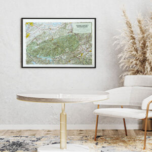
Raised relief maps look impressive on their own but framing takes them to a whole new level. A framed raised relief map serves as functional sculpture and transforms the map into a true centerpiece—ideal for offices, living rooms, conference rooms, or gift-giving. The added visual weight of a frame draws the eye and gives the map a finished, intentional look that enhances any space. If you’re investing in a raised relief map, framing is the upgrade that makes it unforgettable and elevates it from educational tool to display-worthy art. Raised relief maps are typically not framed under glass, since doing so wouldn’t allow access to the 3D surface or may distort its appearance. Instead, these maps are best displayed in an open frame or shadowbox format that preserves the depth and tactile quality of the molded terrain. Some raised relief maps include a built-in molded border for added structure and durability. The wood frame is placed outside the raised surface, creating a timeless double-framed effect that enhances both the map’s dimensionality and overall presentation.
Raised relief maps look impressive on their own but framing takes them to a whole new level. A framed raised relief map serves as functional sculpture and transforms the map into a true centerpiece—ideal for offices, living rooms, conference rooms, or gift-giving. The added visual weight of a frame draws the eye and gives the map a finished, intentional look that enhances any space. If you’re investing in a raised relief map, framing is the upgrade that makes it unforgettable and elevates it from educational tool to display-worthy art. Raised relief maps are typically not framed under glass, since doing so wouldn’t allow access to the 3D surface or may distort its appearance. Instead, these maps are best displayed in an open frame or shadowbox format that preserves the depth and tactile quality of the molded terrain. Some raised relief maps include a built-in molded border for added structure and durability. The wood frame is placed outside the raised surface, creating a timeless double-framed effect that enhances both the map’s dimensionality and overall presentation.
Are Raised Relief Maps Good for Classrooms or Homeschooling?
Absolutely. Raised relief maps are especially effective for tactile and visual learners who benefit from hands-on interaction with geographic concepts. The 3D surface allows students to physically feel elevation changes, helping them grasp features like mountains, valleys, plains, and plateaus in a way that flat maps or screens can’t replicate. These maps are ideal for early learners who are just beginning to understand landform concepts and spatial relationships. For advanced learners, raised relief maps support deeper study of topography, elevation profiles, watersheds, and regional geology, making them useful for middle school, high school, and even college-level courses. Whether in a traditional classroom or a homeschool environment, raised relief maps turn abstract geographic ideas into memorable, multi-sensory learning experiences.
Absolutely. Raised relief maps are especially effective for tactile and visual learners who benefit from hands-on interaction with geographic concepts. The 3D surface allows students to physically feel elevation changes, helping them grasp features like mountains, valleys, plains, and plateaus in a way that flat maps or screens can’t replicate. These maps are ideal for early learners who are just beginning to understand landform concepts and spatial relationships. For advanced learners, raised relief maps support deeper study of topography, elevation profiles, watersheds, and regional geology, making them useful for middle school, high school, and even college-level courses. Whether in a traditional classroom or a homeschool environment, raised relief maps turn abstract geographic ideas into memorable, multi-sensory learning experiences.
Do You Offer Different Sizes?
Yes. Raised relief maps are available in a variety of sizes, depending on the region. Some are compact for desktop use, while others are large enough to serve as a central display or wall décor. Each product page lists the physical dimensions.
Yes. Raised relief maps are available in a variety of sizes, depending on the region. Some are compact for desktop use, while others are large enough to serve as a central display or wall décor. Each product page lists the physical dimensions.
What Is the Hubbard Scientific Brand?
Hubbard Scientific is the most recognized and respected name in raised relief maps, known for their exceptional durability, educational value, and highly detailed terrain. For over 60 years, Hubbard Scientific has been a trusted resource in classrooms across the country, helping students visualize and understand the physical features of our world. Today, the Map Shop is proud to be the sole manufacturer of Hubbard Scientific maps, continuing that legacy with the same commitment to quality and education. Each map is designed with clear labeling, bold elevation features, and rugged construction that stands up to daily classroom use. They’re made in the USA and built specifically for educational environments, with a level of tactile accuracy and vertical exaggeration that makes landforms easy to identify and compare. Whether you’re a teacher, homeschool parent, or institution looking for proven educational tools, Hubbard Scientific maps offer unmatched value and reliability. Learn more about the Hubbard Scientific brand and history here.
Hubbard Scientific is the most recognized and respected name in raised relief maps, known for their exceptional durability, educational value, and highly detailed terrain. For over 60 years, Hubbard Scientific has been a trusted resource in classrooms across the country, helping students visualize and understand the physical features of our world. Today, the Map Shop is proud to be the sole manufacturer of Hubbard Scientific maps, continuing that legacy with the same commitment to quality and education. Each map is designed with clear labeling, bold elevation features, and rugged construction that stands up to daily classroom use. They’re made in the USA and built specifically for educational environments, with a level of tactile accuracy and vertical exaggeration that makes landforms easy to identify and compare. Whether you’re a teacher, homeschool parent, or institution looking for proven educational tools, Hubbard Scientific maps offer unmatched value and reliability. Learn more about the Hubbard Scientific brand and history here.
Why Buy Raised Relief Maps from the Map Shop?
We’ve been helping people explore the world through maps since 1990. Our raised relief map collection is handpicked for accuracy, quality, and visual impact. We are also the exclusive manufacturer of all Hubbard Scientific raised relief maps, continuing a decades-long tradition of educational excellence. You can easily browse and purchase raised relief maps online from our catalog, knowing you’re buying directly from the source. Whether you’re a teacher, traveler, student, or just someone who appreciates geography, we’re here to help you find the right map. Many of our maps are in stock and ready to ship, and our Charlotte, NC team is available to assist if you need help choosing the best option. If you’re looking for a specific area or want help navigating the collection, reach out for personalized guidance.
We’ve been helping people explore the world through maps since 1990. Our raised relief map collection is handpicked for accuracy, quality, and visual impact. We are also the exclusive manufacturer of all Hubbard Scientific raised relief maps, continuing a decades-long tradition of educational excellence. You can easily browse and purchase raised relief maps online from our catalog, knowing you’re buying directly from the source. Whether you’re a teacher, traveler, student, or just someone who appreciates geography, we’re here to help you find the right map. Many of our maps are in stock and ready to ship, and our Charlotte, NC team is available to assist if you need help choosing the best option. If you’re looking for a specific area or want help navigating the collection, reach out for personalized guidance.