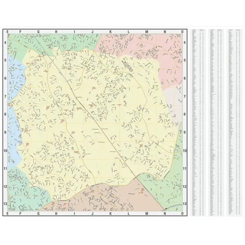
Custom Wall Maps FOR BUSINESS

We have been making custom maps for businesses around the world since 1996. We are proud of the strategic advantage we give customers through a variety of market-oriented maps that are tailored to the geography and data that’s most important.

Who Do We Work With?

With the unlimited possibilities that maps offer, we have companies and corporations reaching out to us all the time with custom map requests! From delivery maps on a specific area to an overall United States map with locations plotted and labeled, we have you covered! Our customer list includes a wide range of organizations like Hollywood Studios, Homeland Security, Jehovah’s Witnesses and Domino’s Pizza. 

Customizable road maps and atlases from The Map Shop, perfect for travelers and outdoor enthusiasts seeking quality map products for navigation and exploration.
Brightly colored Costco Wholesale logo with bold red and blue text, emphasizing bulk shopping, discounts, and warehouse retail stores; ideal for retail, wholesale, and shopping location keywords.
Detailed map and navigation tools from The Map Shop for travel, outdoor adventures, and geographic exploration.
Detailed map of North America showcasing major cities and roads, ideal for travel planning and navigation.
Bundle of maps and atlases for Norfolk Southern Railway, showcasing navigation and rail industry resources. Perfect for train enthusiasts and professionals needing detailed transit maps.

SERVICE AREA Map

A service area map is similar to the regional map, but with the service area distinguished from the rest of the map. 

This can show a service area as one single color or multiple colors. It can also show areas like sales territories, business districts, service zones, or any other areas that are separate from each other.  Common methods used to determine service areas are by counties, by zip codes or by census tracts.  These types of maps can help with planning and strategy for a wide range of applications.

More Information
State map of Florida showing city locations and regional divisions, highlighting detailed cartography and geographic information for travel, navigation, and map enthusiasts.
Detailed map of Florida counties showing roads, cities, and highways, ideal for travel planning, navigation, and geographic reference. Perfect for map enthusiasts and local explorers.

Regional Map

A regional map can cover a single metropolitan area, parts of multiple states, or even several states.

This is type of map is great for strategic overview and can be customized with the detail level you require, depending on the size of the map and total coverage area. 

More Information
Detailed map of the United States with city labels and road networks, perfect for navigation and travel planning from The Map Shop.
Map of Texas and New Mexico showing detailed highways, cities, and transportation routes for accurate navigation and geographic reference.

DELIVERY MAP

On a delivery map, you have a small area with every street labeled and often an index, either on the map or printed in a companion book. 

A delivery map helps with route planning and can greatly increase the efficiency of your drivers.  They also can be used to ensure that you are not delivering to areas that are simply not cost effective to serve.  Delivery areas can either be a defined zone, or simply a radius with your location at the center.

More Information
Map of the local neighborhood and streets, ideal for navigation, trip planning, and outdoor activities. Includes detailed road layouts and landmarks for accurate orientation.
Lexington KY street map with city details, highways, and landmarks, suitable for travelers and locals seeking detailed navigation and geographic information.

Real Estate Map

This is a map of a single city that shows the various neighborhoods in that city.

These maps are great for plotting real estate assets or for use in other local planning strategies.

More Information
Detailed Charlotte, North Carolina city map showing roads, neighborhoods, and landmarks. Perfect for navigation, travel planning, and local exploration.
Detailed map of Bakersfield, California showcasing city neighborhoods, parks, highways, and geographic features, ideal for navigation, travel planning, and geographic reference.

Asset Location Map

Plot business locations, business assets, or other points of interest across a custom map. We can handle and plot any amount of locations.

These maps are great for visualizing where your assets are in relation to each other.  A muted base map often serves to highlight the locations without losing details.

More Information
Route map of New England and New York with district labels for North American road atlas and travel planning purposes.
Map of Atlanta and surrounding areas highlighting healthcare facilities, hospitals, clinics, and important landmarks for navigation and health services.