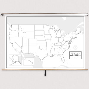
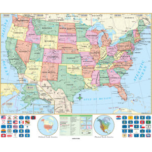
What Are Middle School U.S. Maps?
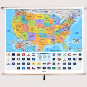
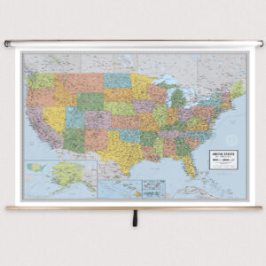
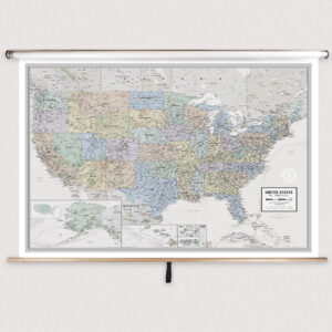
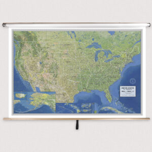
Middle school U.S. maps are educational wall maps mounted on spring rollers that provide a detailed view of the United States. Designed for grades 6–8, these maps highlight state boundaries, capitals, major cities, and physical landforms. Some maps include thematic details such as population density, climate zones, or natural resources, offering comprehensive resources for middle school geography and social studies lessons.
Middle school U.S. maps are educational wall maps mounted on spring rollers that provide a detailed view of the United States. Designed for grades 6–8, these maps highlight state boundaries, capitals, major cities, and physical landforms. Some maps include thematic details such as population density, climate zones, or natural resources, offering comprehensive resources for middle school geography and social studies lessons.
What Are the Different Types of Middle School U.S. Maps?
This category features a variety of U.S. maps tailored for middle school classrooms. Options include political maps focusing on states and capitals, physical maps that highlight mountains, rivers, and terrain, and thematic maps that show environmental and economic information. Each product is designed to support interactive instruction while providing age-appropriate detail for grades 6–8.
This category features a variety of U.S. maps tailored for middle school classrooms. Options include political maps focusing on states and capitals, physical maps that highlight mountains, rivers, and terrain, and thematic maps that show environmental and economic information. Each product is designed to support interactive instruction while providing age-appropriate detail for grades 6–8.
What Are the Benefits of Using U.S. Maps in Middle School Classrooms?
U.S. maps help students understand the nation’s political structure, physical geography, and historical development. Teachers can use these maps to illustrate lessons on migration, regional economies, and environmental changes. Laminated, markable surfaces allow teachers to highlight regions and annotate lessons, fostering interactive learning and improved spatial reasoning.
U.S. maps help students understand the nation’s political structure, physical geography, and historical development. Teachers can use these maps to illustrate lessons on migration, regional economies, and environmental changes. Laminated, markable surfaces allow teachers to highlight regions and annotate lessons, fostering interactive learning and improved spatial reasoning.
Are Middle School U.S. Maps Good for Classrooms, Offices, and Homes?
Yes. While primarily designed for middle school classrooms, these maps are also suitable for homeschooling environments, tutoring centers, and offices that require detailed U.S. geographic references. Families use them to teach children about state geography, track travel routes, and explore American history. The laminated finish ensures durability and long-term usability.
Yes. While primarily designed for middle school classrooms, these maps are also suitable for homeschooling environments, tutoring centers, and offices that require detailed U.S. geographic references. Families use them to teach children about state geography, track travel routes, and explore American history. The laminated finish ensures durability and long-term usability.
What Grade Levels Are Middle School U.S. Maps Designed For?
Middle school U.S. maps are specifically intended for grades 6–8, providing more geographic detail than elementary-level maps while remaining accessible to developing learners. High school U.S. maps offer even more advanced political, physical, and thematic data for older students preparing for higher-level studies.
Middle school U.S. maps are specifically intended for grades 6–8, providing more geographic detail than elementary-level maps while remaining accessible to developing learners. High school U.S. maps offer even more advanced political, physical, and thematic data for older students preparing for higher-level studies.
How Do I Decorate with Middle School U.S. Maps?
Middle school U.S. maps serve as practical teaching tools and visually engaging classroom décor. When rolled up, they store neatly above chalkboards or whiteboards. When displayed, they create an informative focal point that encourages discussion and exploration. At home, these maps can be mounted in study areas to support interactive learning and add educational value.
Middle school U.S. maps serve as practical teaching tools and visually engaging classroom décor. When rolled up, they store neatly above chalkboards or whiteboards. When displayed, they create an informative focal point that encourages discussion and exploration. At home, these maps can be mounted in study areas to support interactive learning and add educational value.
Can I Create a Custom Middle School U.S. Map for My Classroom?
Yes. Custom U.S. maps can be designed specifically for middle school classrooms. Options include combining multiple maps on a single roller, adding district-specific details, or creating thematic maps tailored to curriculum needs. Each custom map is assembled in-house with high-quality materials to ensure accuracy and durability. Learn more about custom solutions at this page.
Yes. Custom U.S. maps can be designed specifically for middle school classrooms. Options include combining multiple maps on a single roller, adding district-specific details, or creating thematic maps tailored to curriculum needs. Each custom map is assembled in-house with high-quality materials to ensure accuracy and durability. Learn more about custom solutions at this page.
How Do I Install Middle School U.S. Maps?
Installation is quick and simple. These maps are designed for mounting above whiteboards or on flat walls, with both wall and ceiling installation options available. Units ordered with backboards come pre-attached for hassle-free setup. Following installation instructions ensures a secure fit and smooth roller function. Instructions are available at this link.
Installation is quick and simple. These maps are designed for mounting above whiteboards or on flat walls, with both wall and ceiling installation options available. Units ordered with backboards come pre-attached for hassle-free setup. Following installation instructions ensures a secure fit and smooth roller function. Instructions are available at this link.
Do You Sell Mounting Hardware for Middle School U.S. Maps?
Yes. We offer mounting hardware, including brackets, backboards, and accessories specifically for middle school U.S. maps. Each map order includes backboards and wall brackets, but screws and anchors must be selected based on your wall type. Browse available hardware options at this page.
Yes. We offer mounting hardware, including brackets, backboards, and accessories specifically for middle school U.S. maps. Each map order includes backboards and wall brackets, but screws and anchors must be selected based on your wall type. Browse available hardware options at this page.
What Materials Are Used for Middle School U.S. Maps?
Each U.S. map is printed on heavyweight paper and laminated to provide a markable, easy-to-clean surface. The laminated finish supports both dry-erase and wet-erase markers, making lessons interactive and customizable. Powder-coated steel backboards provide stability and ensure that maps can handle frequent classroom use.
Each U.S. map is printed on heavyweight paper and laminated to provide a markable, easy-to-clean surface. The laminated finish supports both dry-erase and wet-erase markers, making lessons interactive and customizable. Powder-coated steel backboards provide stability and ensure that maps can handle frequent classroom use.
What Do Maps Teach Middle School Students?
U.S. maps teach students about the country’s political divisions, natural features, and cultural regions. Teachers can use these maps to explain migration patterns, regional industries, and environmental diversity. Pull-down maps enable interactive lessons that help students connect historical events and geographic knowledge for a deeper understanding of the United States.
U.S. maps teach students about the country’s political divisions, natural features, and cultural regions. Teachers can use these maps to explain migration patterns, regional industries, and environmental diversity. Pull-down maps enable interactive lessons that help students connect historical events and geographic knowledge for a deeper understanding of the United States.
What Are the Available Sizes of Middle School U.S. Maps?
Middle school U.S. maps come in various sizes to fit different classroom layouts. Larger maps are perfect for group instruction, while smaller maps are ideal for compact spaces. Exact dimensions for each product can be found on the individual product pages within this category.
Middle school U.S. maps come in various sizes to fit different classroom layouts. Larger maps are perfect for group instruction, while smaller maps are ideal for compact spaces. Exact dimensions for each product can be found on the individual product pages within this category.
What is BrightWay Educational?
BrightWay Educational is our exclusive line of classroom maps, including middle school U.S. maps. Updated frequently with the latest political and geographic data, BrightWay maps feature detailed cartography, clear labeling, and vibrant colors tailored to grades 6–8. Learn more about BrightWay Educational maps here.
BrightWay Educational is our exclusive line of classroom maps, including middle school U.S. maps. Updated frequently with the latest political and geographic data, BrightWay maps feature detailed cartography, clear labeling, and vibrant colors tailored to grades 6–8. Learn more about BrightWay Educational maps here.
Why Choose The Map Shop for Middle School U.S. Maps?
Since 1990, The Map Shop has been a trusted source of educational maps for schools nationwide. Each middle school U.S. map is hand-finished in our Charlotte, NC facility using premium materials and professional assembly techniques. We focus on accuracy, durability, and visually engaging designs that support effective learning. Read customer reviews here or learn more about our story here.
Since 1990, The Map Shop has been a trusted source of educational maps for schools nationwide. Each middle school U.S. map is hand-finished in our Charlotte, NC facility using premium materials and professional assembly techniques. We focus on accuracy, durability, and visually engaging designs that support effective learning. Read customer reviews here or learn more about our story here.