What Are High School and College U.S. Maps?
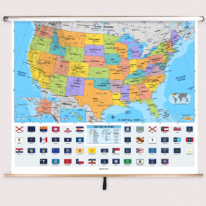
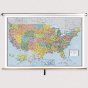
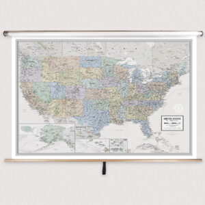
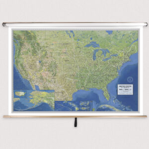
High school and college U.S. maps are large-format wall maps mounted on spring rollers that provide detailed geographic information about the United States. These maps include political boundaries, state capitals, major cities, and physical features such as mountain ranges, rivers, and plains. Many maps also offer thematic data, including climate zones, population density, and regional industries, supporting advanced studies in geography, history, and economics.
High school and college U.S. maps are large-format wall maps mounted on spring rollers that provide detailed geographic information about the United States. These maps include political boundaries, state capitals, major cities, and physical features such as mountain ranges, rivers, and plains. Many maps also offer thematic data, including climate zones, population density, and regional industries, supporting advanced studies in geography, history, and economics.
What Are the Different Types of High School and College U.S. Maps?
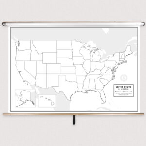
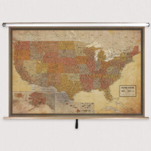
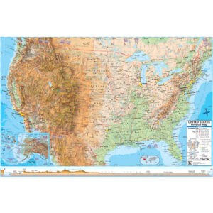
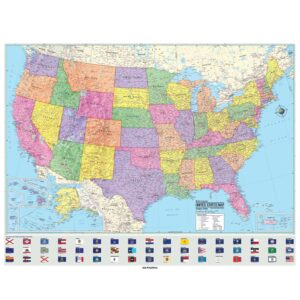
This category includes a wide range of U.S. maps for advanced instruction. Teachers can choose from political maps focusing on states and capitals, physical maps highlighting terrain and natural features, and thematic maps addressing topics such as demographics, climate, and economic activity. Each product is designed to meet the needs of high school and college-level coursework.
This category includes a wide range of U.S. maps for advanced instruction. Teachers can choose from political maps focusing on states and capitals, physical maps highlighting terrain and natural features, and thematic maps addressing topics such as demographics, climate, and economic activity. Each product is designed to meet the needs of high school and college-level coursework.
What Are the Benefits of Using U.S. Maps in Advanced Classrooms?
U.S. maps help students analyze the country’s political divisions, physical landscapes, and cultural regions in detail. Teachers can use these maps to explain historical territorial changes, migration patterns, environmental challenges, and regional economies. Laminated, markable surfaces support interactive lessons that engage students in critical thinking and spatial analysis.
U.S. maps help students analyze the country’s political divisions, physical landscapes, and cultural regions in detail. Teachers can use these maps to explain historical territorial changes, migration patterns, environmental challenges, and regional economies. Laminated, markable surfaces support interactive lessons that engage students in critical thinking and spatial analysis.
Are High School and College U.S. Maps Good for Classrooms, Offices, and Homes?
Yes. While primarily designed for advanced classrooms, these maps are also useful in research centers, tutoring environments, and educational offices. Families with older students can use them to support high-level studies of American history and geography. Built with durable materials and easy-to-clean laminated finishes, these maps withstand frequent use in any academic setting.
Yes. While primarily designed for advanced classrooms, these maps are also useful in research centers, tutoring environments, and educational offices. Families with older students can use them to support high-level studies of American history and geography. Built with durable materials and easy-to-clean laminated finishes, these maps withstand frequent use in any academic setting.
What Grade Levels Are High School and College U.S. Maps Designed For?
These maps are specifically intended for grades 9–12 and higher education. They provide detailed political, physical, and thematic information required for advanced coursework. Elementary and middle school maps are available with simplified layouts for younger learners.
These maps are specifically intended for grades 9–12 and higher education. They provide detailed political, physical, and thematic information required for advanced coursework. Elementary and middle school maps are available with simplified layouts for younger learners.
How Do I Decorate with High School and College U.S. Maps?
U.S. maps serve as functional teaching tools and academic décor. When rolled up, they store neatly above whiteboards or chalkboards. When displayed, they create an engaging focal point that supports lessons in geography, history, and political science. In study rooms or offices, these maps add professional and educational value to the space.
U.S. maps serve as functional teaching tools and academic décor. When rolled up, they store neatly above whiteboards or chalkboards. When displayed, they create an engaging focal point that supports lessons in geography, history, and political science. In study rooms or offices, these maps add professional and educational value to the space.
Can I Create a Custom High School or College U.S. Map for My Classroom?
Yes. We can design custom U.S. maps for high school and college classrooms. Options include combining multiple U.S. maps with thematic or regional maps on one roller, adding district-specific details, or customizing data for specialized coursework. Each custom map is hand-assembled with premium materials for accuracy and long-lasting use. Learn more at this page.
Yes. We can design custom U.S. maps for high school and college classrooms. Options include combining multiple U.S. maps with thematic or regional maps on one roller, adding district-specific details, or customizing data for specialized coursework. Each custom map is hand-assembled with premium materials for accuracy and long-lasting use. Learn more at this page.
How Do I Install High School and College U.S. Maps?
Installation is simple and secure. These maps are designed to mount above whiteboards or on flat walls, with options for wall and ceiling mounting. Units ordered with backboards come pre-attached for easy installation. Proper installation ensures stability and smooth spring roller operation. Detailed instructions are available at this link.
Installation is simple and secure. These maps are designed to mount above whiteboards or on flat walls, with options for wall and ceiling mounting. Units ordered with backboards come pre-attached for easy installation. Proper installation ensures stability and smooth spring roller operation. Detailed instructions are available at this link.
Do You Sell Mounting Hardware for High School and College U.S. Maps?
Yes. We offer mounting hardware, including brackets, backboards, and accessories specifically for high school and college U.S. maps. Each order includes backboards and wall brackets, but screws and anchors must be chosen based on your wall material. Browse available hardware at this page.
Yes. We offer mounting hardware, including brackets, backboards, and accessories specifically for high school and college U.S. maps. Each order includes backboards and wall brackets, but screws and anchors must be chosen based on your wall material. Browse available hardware at this page.
What Materials Are Used for High School and College U.S. Maps?
Each map is printed on heavyweight paper, laminated for durability, and mounted on a spring roller. The laminated surface is compatible with dry-erase and wet-erase markers, making lessons interactive and engaging. Powder-coated steel backboards provide long-lasting stability for frequent academic use.
Each map is printed on heavyweight paper, laminated for durability, and mounted on a spring roller. The laminated surface is compatible with dry-erase and wet-erase markers, making lessons interactive and engaging. Powder-coated steel backboards provide long-lasting stability for frequent academic use.
What Do Maps Teach High School and College Students?
U.S. maps help students gain a deep understanding of the nation’s political, physical, and cultural geography. Teachers can use these maps to explain historical events, regional development, migration trends, and environmental factors. Pull-down maps make lessons interactive and support analytical skills necessary for advanced studies.
U.S. maps help students gain a deep understanding of the nation’s political, physical, and cultural geography. Teachers can use these maps to explain historical events, regional development, migration trends, and environmental factors. Pull-down maps make lessons interactive and support analytical skills necessary for advanced studies.
What Are the Available Sizes of High School and College U.S. Maps?
These maps are available in multiple sizes to suit different classroom and study settings. Larger formats are ideal for group instruction, while smaller maps work well in compact spaces. Exact dimensions for each product are listed on the individual product pages in this category.
These maps are available in multiple sizes to suit different classroom and study settings. Larger formats are ideal for group instruction, while smaller maps work well in compact spaces. Exact dimensions for each product are listed on the individual product pages in this category.
What is BrightWay Educational?
BrightWay Educational is our exclusive line of classroom maps, including U.S. maps designed for high school and college education. Updated frequently to reflect the latest political and geographic changes, BrightWay maps feature precise cartography and thematic data tailored for advanced instruction. Learn more about BrightWay Educational maps here.
BrightWay Educational is our exclusive line of classroom maps, including U.S. maps designed for high school and college education. Updated frequently to reflect the latest political and geographic changes, BrightWay maps feature precise cartography and thematic data tailored for advanced instruction. Learn more about BrightWay Educational maps here.
Why Choose The Map Shop for High School and College U.S. Maps?
Since 1990, The Map Shop has provided high-quality educational maps to schools and universities nationwide. Each U.S. map is hand-finished in our Charlotte, NC facility with premium materials and professional craftsmanship. Our focus on accuracy, durability, and instructional value ensures that educators have reliable tools for advanced teaching. Read customer reviews here or learn more about our history here.
Since 1990, The Map Shop has provided high-quality educational maps to schools and universities nationwide. Each U.S. map is hand-finished in our Charlotte, NC facility with premium materials and professional craftsmanship. Our focus on accuracy, durability, and instructional value ensures that educators have reliable tools for advanced teaching. Read customer reviews here or learn more about our history here.