

What Are Classroom Pull Down Maps?
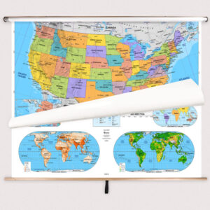
Classroom pull-down maps are essential tools for modern education, designed specifically for geography, history, and social studies instruction. These large-format educational wall maps are mounted on spring rollers, functioning like traditional pull-down charts often installed above chalkboards or whiteboards. Built for frequent use in schools, they provide clear, easy-to-read visuals that help students better understand and retain information. Perfect for grades K–12 and higher education, classroom pull-down maps support collaborative teaching and long-term reference in any learning environment. Many of our maps are aligned with national standards, making them ideal for curriculum-based instruction. Schools often upgrade from paper or laminated wall maps to spring roller pull-down maps for their enhanced durability, clarity, and convenience. When you’re ready to choose the perfect map, you can order directly from our shop and enjoy easy customization options. Want to explore additional types of wall maps? Click here to browse our full collection.
Classroom pull-down maps are essential tools for modern education, designed specifically for geography, history, and social studies instruction. These large-format educational wall maps are mounted on spring rollers, functioning like traditional pull-down charts often installed above chalkboards or whiteboards. Built for frequent use in schools, they provide clear, easy-to-read visuals that help students better understand and retain information. Perfect for grades K–12 and higher education, classroom pull-down maps support collaborative teaching and long-term reference in any learning environment. Many of our maps are aligned with national standards, making them ideal for curriculum-based instruction. Schools often upgrade from paper or laminated wall maps to spring roller pull-down maps for their enhanced durability, clarity, and convenience. When you’re ready to choose the perfect map, you can order directly from our shop and enjoy easy customization options. Want to explore additional types of wall maps? Click here to browse our full collection.
What Are the Different Types of Classroom Pull Down Maps?
We offer a wide range of classroom pull down maps tailored to different grade levels and educational needs, with a lot of options and a variety of styles, colors, and details available. Popular categories include Best-Selling Combo Maps for comprehensive sets, Elementary Classroom Maps for young learners, Middle School Classroom Maps for developing geography skills, and High School & College Classroom Maps for more advanced academic content. You can also explore Custom Spring Roller Maps for specialized needs or Mounting Hardware to complete your classroom setup. The quality and craftsmanship of our finished maps ensure that each piece is designed to be both functional and a great addition to any space.
We offer a wide range of classroom pull down maps tailored to different grade levels and educational needs, with a lot of options and a variety of styles, colors, and details available. Popular categories include Best-Selling Combo Maps for comprehensive sets, Elementary Classroom Maps for young learners, Middle School Classroom Maps for developing geography skills, and High School & College Classroom Maps for more advanced academic content. You can also explore Custom Spring Roller Maps for specialized needs or Mounting Hardware to complete your classroom setup. The quality and craftsmanship of our finished maps ensure that each piece is designed to be both functional and a great addition to any space.
What are the Benefits of Using Maps in the Classroom?
Incorporating maps into classroom instruction provides significant educational benefits. Maps help students visualize global relationships, connect historical events to geographic locations, and understand how natural and political boundaries shape our world. They support differentiated instruction by enabling teachers to tailor lessons to specific grade levels and learning objectives. Maps also enhance student engagement by prompting questions, encouraging exploration, and offering visual clarity that supports memory retention. No matter the grade or subject, maps bring depth and interactivity to the learning experience.
Incorporating maps into classroom instruction provides significant educational benefits. Maps help students visualize global relationships, connect historical events to geographic locations, and understand how natural and political boundaries shape our world. They support differentiated instruction by enabling teachers to tailor lessons to specific grade levels and learning objectives. Maps also enhance student engagement by prompting questions, encouraging exploration, and offering visual clarity that supports memory retention. No matter the grade or subject, maps bring depth and interactivity to the learning experience.
Are the Maps Good for Classrooms, Offices, and Homes?
Yes. Classroom Pull Down Maps are versatile and useful in a wide range of settings. Teachers use them to reinforce geographic learning. Offices and business environments display them for global strategy, planning, and professional decor. Families and travelers use them to track visits or plan future adventures, including tracking travel each year. A classy, antique-style wall map can serve as a piece of art and a focal point in an office or family room. Whether you’re marking countries visited, teaching global awareness, or decorating a shared space, world maps provide both style and substance. These maps are ideal for educational, business, and family settings, and their lamination ensures durability and easy cleaning. Selecting the right map will ensure it fits your specific needs.
Yes. Classroom Pull Down Maps are versatile and useful in a wide range of settings. Teachers use them to reinforce geographic learning. Offices and business environments display them for global strategy, planning, and professional decor. Families and travelers use them to track visits or plan future adventures, including tracking travel each year. A classy, antique-style wall map can serve as a piece of art and a focal point in an office or family room. Whether you’re marking countries visited, teaching global awareness, or decorating a shared space, world maps provide both style and substance. These maps are ideal for educational, business, and family settings, and their lamination ensures durability and easy cleaning. Selecting the right map will ensure it fits your specific needs.
What Grade Levels Are These Maps Designed For?
Our classroom wall maps are designed to meet the needs of different grade levels. Elementary Classroom Maps feature bold colors, simplified labeling, and intuitive layouts to support early learners. Middle School Classroom Maps introduce more complex data while remaining accessible. High School & College Classroom Maps incorporate detailed political, physical, and thematic information for advanced study. Each map is thoughtfully designed to align with the cognitive and curriculum needs of the intended age group.
Our classroom wall maps are designed to meet the needs of different grade levels. Elementary Classroom Maps feature bold colors, simplified labeling, and intuitive layouts to support early learners. Middle School Classroom Maps introduce more complex data while remaining accessible. High School & College Classroom Maps incorporate detailed political, physical, and thematic information for advanced study. Each map is thoughtfully designed to align with the cognitive and curriculum needs of the intended age group.
How Do I Decorate with Classroom Pull Down Maps?
Classroom Pull Down Maps can transform a room. When selecting one, consider the size, color scheme, and design to make sure it fits with your décor. A framed map adds a polished, professional look. Laminated maps are durable and easy to clean. Foam-mounted maps are great for pins and visual tracking. The right finish can make the map come alive in your space, enhancing both its visual appeal and functionality. The colors and detail of a world wall map can enhance the aesthetic of any room, making it a perfect map for both function and art. Classroom Pull Down Maps can spark conversation, highlight global awareness, and reflect your interests. Use one to create an inspiring focal point in your home, classroom, or workspace.
Classroom Pull Down Maps can transform a room. When selecting one, consider the size, color scheme, and design to make sure it fits with your décor. A framed map adds a polished, professional look. Laminated maps are durable and easy to clean. Foam-mounted maps are great for pins and visual tracking. The right finish can make the map come alive in your space, enhancing both its visual appeal and functionality. The colors and detail of a world wall map can enhance the aesthetic of any room, making it a perfect map for both function and art. Classroom Pull Down Maps can spark conversation, highlight global awareness, and reflect your interests. Use one to create an inspiring focal point in your home, classroom, or workspace.
Can I Create a Custom Spring Roller Map for My Classroom?
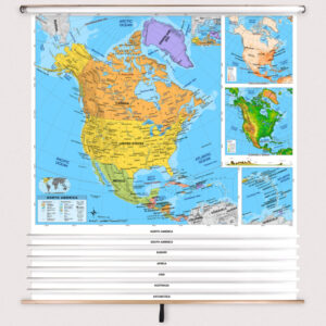
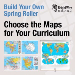
Yes, custom spring roller maps are one of our specialties. If you need a solution beyond standard classroom maps, we can build a spring roller unit tailored to your specific needs. This includes combining multiple maps—such as U.S., world, and state maps—on a single pull-down roller, or designing maps with unique combinations of political, physical, or thematic content. We also produce branded and district-specific maps for schools, education systems, and resellers. All of our custom spring roller maps are assembled in-house using high-quality materials and are available with optional backboards for mounting. Whether you’re outfitting a single classroom or an entire district, we can help you design the ideal solution. Click here to learn more.
Yes, custom spring roller maps are one of our specialties. If you need a solution beyond standard classroom maps, we can build a spring roller unit tailored to your specific needs. This includes combining multiple maps—such as U.S., world, and state maps—on a single pull-down roller, or designing maps with unique combinations of political, physical, or thematic content. We also produce branded and district-specific maps for schools, education systems, and resellers. All of our custom spring roller maps are assembled in-house using high-quality materials and are available with optional backboards for mounting. Whether you’re outfitting a single classroom or an entire district, we can help you design the ideal solution. Click here to learn more.
How Do I Install a Classroom Pull-Down Map?
Installing a spring roller map is simple, and we provide detailed resources to guide you through the process. Most classroom pull-down maps are designed to mount above a whiteboard or flat wall. Depending on your space, you can choose wall-mount or ceiling-mount installation. Maps ordered with a backboard come pre-attached and ready to hang. If you’re installing a multi-map combo or replacing an older unit, following proper installation steps ensures a secure and functional setup. Click here for full instructions.
Installing a spring roller map is simple, and we provide detailed resources to guide you through the process. Most classroom pull-down maps are designed to mount above a whiteboard or flat wall. Depending on your space, you can choose wall-mount or ceiling-mount installation. Maps ordered with a backboard come pre-attached and ready to hang. If you’re installing a multi-map combo or replacing an older unit, following proper installation steps ensures a secure and functional setup. Click here for full instructions.
Do You Sell Mounting Hardware for Pull-Down Maps?
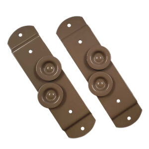
Yes, we offer a complete line of mounting hardware designed for use with classroom spring roller maps. Whether you’re installing a new map or updating an existing one, we carry brackets, backboards, and accessories that provide a secure, long-lasting hold. Hardware options are available for both ceiling and wall installations and are compatible with most spring roller systems. Spring roller backboards and wall brackets are included with all map orders, but installation screws and anchors are not provided. The type of hardware required depends on your wall material—whether it’s drywall, brick, cinderblock, or plaster. You can browse available hardware here.
Yes, we offer a complete line of mounting hardware designed for use with classroom spring roller maps. Whether you’re installing a new map or updating an existing one, we carry brackets, backboards, and accessories that provide a secure, long-lasting hold. Hardware options are available for both ceiling and wall installations and are compatible with most spring roller systems. Spring roller backboards and wall brackets are included with all map orders, but installation screws and anchors are not provided. The type of hardware required depends on your wall material—whether it’s drywall, brick, cinderblock, or plaster. You can browse available hardware here.
What Materials are Used for the Maps?
Each classroom map is printed on high-quality paper, then laminated and mounted on a spring roller for long-lasting use. The laminated surface is markable, allowing teachers to write with both dry-erase and wet-erase markers, and clean it easily. These maps are built to endure daily classroom activity while maintaining clarity and performance. The optional backboards are constructed from powder-coated steel for maximum durability. We also offer multi-map combos mounted on a single roller to conserve wall space and increase functionality.
Each classroom map is printed on high-quality paper, then laminated and mounted on a spring roller for long-lasting use. The laminated surface is markable, allowing teachers to write with both dry-erase and wet-erase markers, and clean it easily. These maps are built to endure daily classroom activity while maintaining clarity and performance. The optional backboards are constructed from powder-coated steel for maximum durability. We also offer multi-map combos mounted on a single roller to conserve wall space and increase functionality.
What Do Maps Teach Students?
Using maps in the classroom transforms lessons into immersive, interactive experiences. Educators can use maps to highlight key historical migrations, display physical features like mountain ranges and rivers, or compare political boundaries across time periods. Introducing a map at the beginning of a lesson invites students to ask questions, locate key areas, and engage with the material visually. Maps also teach spatial reasoning and geographic awareness, skills that extend far beyond the classroom. Maps help students connect abstract ideas to real-world locations and build a deeper understanding of the subject matter.
Using maps in the classroom transforms lessons into immersive, interactive experiences. Educators can use maps to highlight key historical migrations, display physical features like mountain ranges and rivers, or compare political boundaries across time periods. Introducing a map at the beginning of a lesson invites students to ask questions, locate key areas, and engage with the material visually. Maps also teach spatial reasoning and geographic awareness, skills that extend far beyond the classroom. Maps help students connect abstract ideas to real-world locations and build a deeper understanding of the subject matter.
What Are the Available Sizes of the Maps?
Our maps come in a range of sizes depending on how the original map was published and its intended use. There is no universal sizing. To see exact dimensions for each map, check the individual product page for available options.
Our maps come in a range of sizes depending on how the original map was published and its intended use. There is no universal sizing. To see exact dimensions for each map, check the individual product page for available options.
What is BrightWay Educational?
The BrightWay Educational line is the Map Shop’s exclusive brand of classroom pull-down maps, developed with an emphasis on clarity, accuracy, and unmatched cartographic detail. These maps are the most current classroom maps available because we update them regularly to reflect the latest geographic and political changes. With enhanced labeling, clean design, and thorough coverage of physical and political features, BrightWay Educational maps are built for classrooms that demand the highest standards in instructional tools. Created by professional cartographers and educator consultants, these maps are a favorite among schools that want more than just basic reference materials. Click here to view the full collection.
The BrightWay Educational line is the Map Shop’s exclusive brand of classroom pull-down maps, developed with an emphasis on clarity, accuracy, and unmatched cartographic detail. These maps are the most current classroom maps available because we update them regularly to reflect the latest geographic and political changes. With enhanced labeling, clean design, and thorough coverage of physical and political features, BrightWay Educational maps are built for classrooms that demand the highest standards in instructional tools. Created by professional cartographers and educator consultants, these maps are a favorite among schools that want more than just basic reference materials. Click here to view the full collection.
Why Choose The Map Shop for Classroom Maps?
Since 1990, the Map Shop has helped educators across the country bring geography and history lessons to life. All maps are finished in-house at our Charlotte, NC facility using premium materials and proven production methods. Our catalog includes one of the largest online selections of educational wall maps, with solutions for every grade level and subject area. Whether you’re equipping one classroom or an entire district, we’re here to provide expert guidance and dependable products that make a difference in the classroom. Want to know what customers are saying? Read reviews here. Curious about our story? Learn more about The Map Shop.
Since 1990, the Map Shop has helped educators across the country bring geography and history lessons to life. All maps are finished in-house at our Charlotte, NC facility using premium materials and proven production methods. Our catalog includes one of the largest online selections of educational wall maps, with solutions for every grade level and subject area. Whether you’re equipping one classroom or an entire district, we’re here to provide expert guidance and dependable products that make a difference in the classroom. Want to know what customers are saying? Read reviews here. Curious about our story? Learn more about The Map Shop.