What Are World Raised Relief Maps?
World raised relief maps are large-format 3D maps that display Earth’s physical features using molded elevation. These maps use real elevation data and vertical exaggeration to emphasize landforms such as mountain ranges, river basins, highlands, and ocean floors. They are vacuum-formed from rigid vinyl and built for both durability and detail. Whether you’re using one in a classroom, office, or home setting, world raised relief maps provide a hands-on way to explore global geography that is much more engaging than flat maps.
World raised relief maps are large-format 3D maps that display Earth’s physical features using molded elevation. These maps use real elevation data and vertical exaggeration to emphasize landforms such as mountain ranges, river basins, highlands, and ocean floors. They are vacuum-formed from rigid vinyl and built for both durability and detail. Whether you’re using one in a classroom, office, or home setting, world raised relief maps provide a hands-on way to explore global geography that is much more engaging than flat maps.
What Can You See on a World Relief Map?
World raised relief maps show major landforms across continents and oceans, including the Andes, Alps, Rockies, Himalayas, and the Sahara Desert. Many models also include molded ocean floors, allowing you to explore features such as mid-ocean ridges and deep-sea trenches. These maps typically feature country borders, city names, rivers, and labels for major geographic features, which makes them useful for both physical geography and general reference.
World raised relief maps show major landforms across continents and oceans, including the Andes, Alps, Rockies, Himalayas, and the Sahara Desert. Many models also include molded ocean floors, allowing you to explore features such as mid-ocean ridges and deep-sea trenches. These maps typically feature country borders, city names, rivers, and labels for major geographic features, which makes them useful for both physical geography and general reference.
Why Choose a 3D Map of the World?
Flat world maps are great for showing political boundaries and place names, but they cannot convey elevation and terrain. A 3D world raised relief map allows you to physically feel the Earth’s surface, making concepts like mountain ranges, tectonic plates, and elevation much easier to grasp. These maps are ideal for classrooms, travel-themed offices, or anyone with an interest in world geography. They also make excellent gifts for travelers, educators, or anyone who enjoys global exploration.
Flat world maps are great for showing political boundaries and place names, but they cannot convey elevation and terrain. A 3D world raised relief map allows you to physically feel the Earth’s surface, making concepts like mountain ranges, tectonic plates, and elevation much easier to grasp. These maps are ideal for classrooms, travel-themed offices, or anyone with an interest in world geography. They also make excellent gifts for travelers, educators, or anyone who enjoys global exploration.
Are These Maps Accurate?
Yes. Our world raised relief maps are made using accurate global elevation data and scaled to fit each map’s dimensions. Some models use vertical exaggeration to make terrain features stand out more clearly, but the overall elevation relationships are still true to form. Our team ensures each map is clearly labeled, well-molded, and visually balanced so it can serve as both a teaching tool and a display piece.
Yes. Our world raised relief maps are made using accurate global elevation data and scaled to fit each map’s dimensions. Some models use vertical exaggeration to make terrain features stand out more clearly, but the overall elevation relationships are still true to form. Our team ensures each map is clearly labeled, well-molded, and visually balanced so it can serve as both a teaching tool and a display piece.
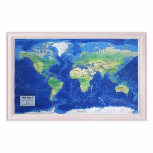
Can You Frame a World Raised Relief Map?
Framing a world raised relief map turns it into a bold visual centerpiece. These maps are not typically framed under glass, since that would compress the 3D surface and reduce its tactile value. Many models include a molded border for added structure, and we offer shadowbox-style framing that enhances the look while preserving the depth. A framed world map is a great addition to classrooms, offices, or home walls.
Framing a world raised relief map turns it into a bold visual centerpiece. These maps are not typically framed under glass, since that would compress the 3D surface and reduce its tactile value. Many models include a molded border for added structure, and we offer shadowbox-style framing that enhances the look while preserving the depth. A framed world map is a great addition to classrooms, offices, or home walls.
Are These Maps Good for Education?
Absolutely. World raised relief maps are highly effective for teaching physical geography, global landforms, and spatial awareness. They help students understand the location and scale of continents, mountain ranges, and tectonic features. Tactile learners especially benefit from physically exploring elevation and landform relationships. These maps are ideal for middle school, high school, or homeschool classrooms.
Absolutely. World raised relief maps are highly effective for teaching physical geography, global landforms, and spatial awareness. They help students understand the location and scale of continents, mountain ranges, and tectonic features. Tactile learners especially benefit from physically exploring elevation and landform relationships. These maps are ideal for middle school, high school, or homeschool classrooms.
What Size Are World Relief Maps?
Sizes vary by product, but most world raised relief maps are between 32 and 40 inches wide. This size allows for detailed viewing of continents and terrain while still fitting well in classrooms or display areas. Each product page includes the exact dimensions and available framing options.
Sizes vary by product, but most world raised relief maps are between 32 and 40 inches wide. This size allows for detailed viewing of continents and terrain while still fitting well in classrooms or display areas. Each product page includes the exact dimensions and available framing options.
What Is the Hubbard Scientific Brand?
Hubbard Scientific is a well-established name in raised relief maps, known for durability, educational value, and highly detailed terrain. For more than 60 years, Hubbard Scientific has been a trusted resource in classrooms, helping students visualize and understand physical geography. Today, The Map Shop is proud to be the sole manufacturer of Hubbard Scientific maps and continues to uphold the brand’s commitment to quality. Each map is made in the USA and designed for educational environments with clear labels, strong molding, and accurate vertical exaggeration. Learn more about the Hubbard Scientific brand and history here.
Hubbard Scientific is a well-established name in raised relief maps, known for durability, educational value, and highly detailed terrain. For more than 60 years, Hubbard Scientific has been a trusted resource in classrooms, helping students visualize and understand physical geography. Today, The Map Shop is proud to be the sole manufacturer of Hubbard Scientific maps and continues to uphold the brand’s commitment to quality. Each map is made in the USA and designed for educational environments with clear labels, strong molding, and accurate vertical exaggeration. Learn more about the Hubbard Scientific brand and history here.
Why Buy World Raised Relief Maps from The Map Shop?
The Map Shop is the exclusive manufacturer of all Hubbard Scientific raised relief maps and has been serving educators, map lovers, and institutions since 1990. Our world raised relief maps are selected for accuracy, visual appeal, and quality construction. Every map is crafted in our Charlotte, NC facility and can be shipped directly to your door. Whether you want to inspire curiosity in the classroom or bring a global perspective to your space, we can help you find the perfect map.
The Map Shop is the exclusive manufacturer of all Hubbard Scientific raised relief maps and has been serving educators, map lovers, and institutions since 1990. Our world raised relief maps are selected for accuracy, visual appeal, and quality construction. Every map is crafted in our Charlotte, NC facility and can be shipped directly to your door. Whether you want to inspire curiosity in the classroom or bring a global perspective to your space, we can help you find the perfect map.