What Are 'Other' Raised Relief Maps?
This category includes raised relief maps that do not fit into our main groupings like United States, States, World, or National Parks. These maps still feature three-dimensional molded terrain and are made using the same vacuum-formed process with accurate elevation data. They may cover smaller countries, specific landforms, or regions with less common coverage.
This category includes raised relief maps that do not fit into our main groupings like United States, States, World, or National Parks. These maps still feature three-dimensional molded terrain and are made using the same vacuum-formed process with accurate elevation data. They may cover smaller countries, specific landforms, or regions with less common coverage.
What Kinds of Maps Are Included?
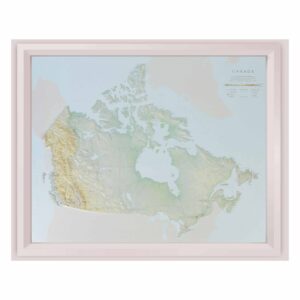
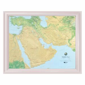
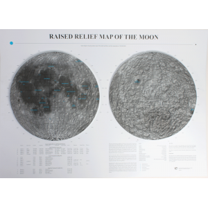
You’ll find maps of individual countries such as Switzerland and Israel, along with regional and specialty maps that focus on terrain rather than political boundaries. Some may include high-elevation island chains, mountain zones, or specialized educational content. This is the place to find rare and niche 3D maps that aren’t widely produced.
You’ll find maps of individual countries such as Switzerland and Israel, along with regional and specialty maps that focus on terrain rather than political boundaries. Some may include high-elevation island chains, mountain zones, or specialized educational content. This is the place to find rare and niche 3D maps that aren’t widely produced.
Who Should Buy These Maps?
These raised relief maps are ideal for collectors, educators, or anyone with a specific interest in a geographic area not covered by standard categories. They’re also excellent for classrooms or university departments that want to offer broader global coverage or focus on comparative landform study.
These raised relief maps are ideal for collectors, educators, or anyone with a specific interest in a geographic area not covered by standard categories. They’re also excellent for classrooms or university departments that want to offer broader global coverage or focus on comparative landform study.
Are These Maps Accurate?
Yes. All maps in this category are developed using accurate elevation data and modeled to reflect real topography. Some may include vertical exaggeration to enhance landform visibility, especially in smaller map formats. Each product page includes details on scale, material, and labeling.
Yes. All maps in this category are developed using accurate elevation data and modeled to reflect real topography. Some may include vertical exaggeration to enhance landform visibility, especially in smaller map formats. Each product page includes details on scale, material, and labeling.
Can You Frame These Relief Maps?
Yes. Just like our other 3D maps, these can be framed in shadowboxes or displayed in open formats that preserve the three-dimensional surface. Framing adds impact and helps protect the map while turning it into a unique display piece for your home, office, or classroom.
Yes. Just like our other 3D maps, these can be framed in shadowboxes or displayed in open formats that preserve the three-dimensional surface. Framing adds impact and helps protect the map while turning it into a unique display piece for your home, office, or classroom.
Are These Maps Good for Education?
Definitely. These maps are useful for teaching world geography, international relations, landform comparison, and regional studies. Their tactile surface helps students explore terrain visually and physically, which makes complex landforms easier to understand. They’re also great for interdisciplinary topics like environmental science or global history.
Definitely. These maps are useful for teaching world geography, international relations, landform comparison, and regional studies. Their tactile surface helps students explore terrain visually and physically, which makes complex landforms easier to understand. They’re also great for interdisciplinary topics like environmental science or global history.
What Sizes Are Available?
Sizes vary widely depending on the region and manufacturer, but most maps in this category fall between 15 and 30 inches wide. Product pages include exact measurements and recommended uses.
Sizes vary widely depending on the region and manufacturer, but most maps in this category fall between 15 and 30 inches wide. Product pages include exact measurements and recommended uses.
What Is the Hubbard Scientific Brand?
Hubbard Scientific is a leading producer of educational raised relief maps and has a long-standing reputation for clarity, durability, and accuracy. The Map Shop is the exclusive manufacturer of all Hubbard Scientific maps, including specialty and less common pieces. Learn more about the Hubbard Scientific brand and history here.
Hubbard Scientific is a leading producer of educational raised relief maps and has a long-standing reputation for clarity, durability, and accuracy. The Map Shop is the exclusive manufacturer of all Hubbard Scientific maps, including specialty and less common pieces. Learn more about the Hubbard Scientific brand and history here.
Why Buy From The Map Shop?
The Map Shop is the exclusive source for all Hubbard Scientific raised relief maps, including unique and hard-to-find regions. We’ve been producing quality maps in Charlotte, NC since 1990 and work directly with educators, collectors, and institutions. If you’re looking for a raised relief map that’s not part of our standard categories, this is where you’ll find it—and our team is always ready to help you track down exactly what you need.
The Map Shop is the exclusive source for all Hubbard Scientific raised relief maps, including unique and hard-to-find regions. We’ve been producing quality maps in Charlotte, NC since 1990 and work directly with educators, collectors, and institutions. If you’re looking for a raised relief map that’s not part of our standard categories, this is where you’ll find it—and our team is always ready to help you track down exactly what you need.